1.3. Mobility Corridor
Aus Pattern Language Wiki
In a Polycentric Region, develop proper high-speed connections between the centers of the region as well as to other regions.
Problem-statement: There is a need for corridors that allow high-speed vehicular movement within and between cities. This need extends into the hearts of the cities. But these structures must not be allowed to sever and destroy the tissue of the city.
Discussion:: Few structures have been more damaging to modern cities than freeways. Yet the solution of creating freeway bypasses on the outskirts of cities is equally disastrous — sapping the centers of commercial movement and activity, and at the same time generating new sprawling zones at the edges.
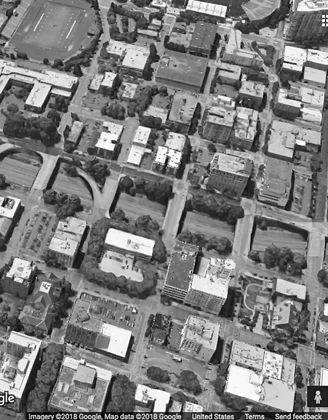
This is not a unique problem of the automobile age. Railways can be no less destructive of urban areas, and so can canals, rivers and other structures — in fact, any structure that significantly interrupts the connectivity and flow of pedestrians is likely to be problematic. But there are excellent examples of cities that have managed this problem, by separating the grades of the mobility corridors, and by creating a continuous fabric of connections across them. Examples can be seen in London, Paris, and many other mature cities.
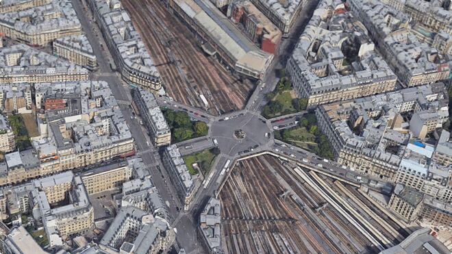
The issue is not whether a mobility corridor is present, but whether the urban fabric surrounding it remains intact. This must be done carefully, maintaining a continuous, tight fabric with minimal intrusion of noise, emissions, and visual disorder. Examples like Place de l’Europe in Paris demonstrate the value of ample vegetation, fences and other screening devices. Some cities have simply taken their mobility corridors underground, like Oslo. Some cities bring buildings across the bridging structures, like the Ponte Vecchio in Florence.¹
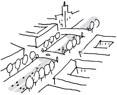
One problem for many cities is the cost of excavation and retaining structures. One strategy to minimize this cost is a “balanced cut and fill” grade change, rising gently in the urban fabric to the edge of the mobility corridor, and then cut more deeply to accommodate travel lanes at a lower grade. A related strategy is to utilize existing natural watershed grade changes, taking care to avoid water pollution from vehicle emissions and other toxic runoff. Because of the cost of excavation, many cities in recent decades have chosen the easier alternative, which is to raise highways and heavy transport tracks above the pedestrian urban fabric. But the evidence shows that there is a profoundly negative impact of such solutions on the urban life underneath them.²
Of course, it must be stressed that “mobility” is not just about high speed transportation, but about integrated mobility across multiple modes (see Walkable Multi-Mobility, 2.1). A coordinated strategy is needed to keep a balanced and integrated approach to mobility.³
Therefore:
Do not push freeways, railways and other destructive activities to the edges of the city. Instead, find ways to integrate them into the urban fabric with minimal disruption, using careful grade-separating strategies. Assure that the streets above are continuous, walkable, and as protected as possible from negative impacts like noise and emissions. Plan for at least two major mobility corridors crossing each large urban area, and connecting to others.
Integrate mobility corridors into the network, maintaining a 400M Through Street Network across all interruptions, providing bridges and other connections…
For a discussion of this concept in relation to urban mobility networks, see Mehaffy M.W., Porta, S., Rofè, Y. and Salingaros, N. (2010), Urban nuclei and the geometry of streets: The ‘emergent neighbourhoods’ model. Urban Design International, 15(1), 22-46.
² The damaging effects of such structures has been discussed extensively, and perhaps most notably by Jane Jacobs in The Death and Life of Great American Cities (1961, New York: Random House). She referred to the consequences as “galloping gangrene.”
³ Additional resources on this point include the World Resources Institute Sustainable Mobility Strategies, http://wrirosscities.org/sites/default/files/WRR_Transport.pdf. Among their recommendations: 1) Optimize efficiency: Support planning and implementation of higher fuel and vehicle efficiency standards and lower energy consumption and emissions from the transport sector through engagement and research. 2) Electrify fuels: Support adoption of electric vehicles and the transition to electrified transport systems through localized research and direct engagement with stakeholders from multiple sectors. 3) Integrate systems: Support implementation and management of integrated transport systems through directly influencing the planning and implementation of urban transport systems and publishing high-quality research. 4) Shift and align funding and policy: Build capacity for sustainable transport through research, direct technical guidance, policy recommendations, and stakeholder engagement with the public, private, civil society, and donor communities.
An additional resource is the European Commission’s “Green City Tool” on mobility: https://webgate.ec.europa.eu/greencitytool/topic/mobility/guidance.
Mehaffy, M. et al. (2020). MOBILITY CORRIDOR (pattern). In A New Pattern Language for Growing Regions. The Dalles: Sustasis Press. Available at https://pattern-language.wiki/.../Mobility_Corridor
SECTION I:
PATTERNS OF SCALE
1. REGIONAL PATTERNS
Define the large-scale spatial organization…
1.4. 400M THROUGH STREET NETWORK
2. URBAN PATTERNS
Establish essential urban characteristics…
3. STREET PATTERNS
Identify and allocate street types…
4. NEIGHBORHOOD PATTERNS
Define neighborhood-scale elements…
5. SPECIAL USE PATTERNS
Integrate unique urban elements with care…
6. PUBLIC SPACE PATTERNS
Establish the character of the crucial public realm…
7. BLOCK AND PLOT PATTERNS
Lay out the detailed structure of property lines…
8. STREETSCAPE PATTERNS
Configure the street as a welcoming place…
9. BUILDING PATTERNS
Lay out appropriate urban buildings…
10. BUILDING EDGE PATTERNS
Create interior and exterior connectivity…
10.1. INDOOR-OUTDOOR AMBIGUITY
SECTION II:
PATTERNS OF MULTIPLE SCALE
11. GEOMETRIC PATTERNS
Build in coherent geometries at all scales…
11.2. SMALL GROUPS OF ELEMENTS
12. AFFORDANCE PATTERNS
Build in user capacity to shape the environment…
13. RETROFIT PATTERNS
Revitalize and improve existing urban assets …
14. INFORMAL GROWTH PATTERNS
Accommodate “bottom-up” urban growth…
15. CONSTRUCTION PATTERNS
Use the building process to enrich the result…
SECTION III:
PATTERNS OF PROCESS
16. IMPLEMENTATION TOOL PATTERNS
Use tools to achieve successful results…
16.2. ENTITLEMENT STREAMLINING
16.3. NEIGHBORHOOD PLANNING CENTER
17. PROJECT ECONOMICS PATTERNS
Create flows of money that support urban quality…
17.4. ECONOMIES OF PLACE AND DIFFERENTIATION
18. PLACE GOVERNANCE PATTERNS
Processes for making and managing places…
18.3. PUBLIC-PRIVATE PLACE MANAGEMENT
19. AFFORDABILITY PATTERNS
Build in affordability for all incomes…
19.1. INTEGRATED AFFORDABILITY
20. NEW TECHNOLOGY PATTERNS
Integrate new systems without damaging old ones…
20.2. RESPONSIVE TRANSPORTATION NETWORK COMPANY


