20.4. Citizen Data
Aus Pattern Language Wiki
In Slum Upgrade and Urban Regeneration, it is especially important that citizens have access to digital technology to be able to manage their own local issues.
Problem-statement: Many urban problems are known only to the citizens who live there, and reporting is often cumbersome and ineffective.
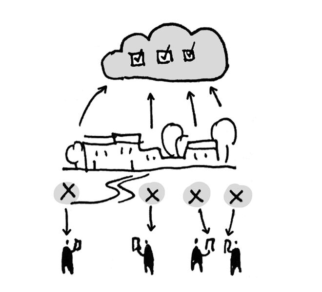
Discussion: A new generation of citizen data is being used to gather information about neighborhood-scale issues and to identify resources that can be brought to bear to address these issues. They include relatively small-scale problems like potholes, graffiti, vandalism, garbage and the like. Citizens armed with a new generation of digital reporting tools can notify agencies, who are able to take this information in an efficient and aggregated form, and develop a response that is locally calibrated to be effective.¹ For example, a community worker can respond to a series of individual reports in sequence, avoiding the need to respond to each report individually (or more often, to simply ignore the reports).
At the same time, we must be aware of worrying trends that create an imperative need for vigilance. Data is being gathered by private entities, to be used (and abused) in surveillance and in manipulating consumers. Since this collection of big data on such a large scale is unprecedented, it is not yet clear how we can prevent it from becoming a tool for manipulation and even oppression. The endless possibilities of using such data towards a positive goal need to be protected from an equally possible abuse.
Therefore:
Use the new digital reporting technologies to respond to neighborhood-scale challenges where they occur, without the need for individual time-consuming and expensive responses by staff.
Work with a local Neighborhood Planning Center to make citizen data available at the grass roots. …
¹ There are a number of groups developing citizen data initiatives, including the Citizen Data Lab at the Amsterdam University of Applied Sciences, faculty of Digital Media and Creative Industries. See citizendatalab.org.
Image: Curtis MacNewton via Unsplash.
Mehaffy, M. et al. (2020). CITIZEN DATA (pattern). In A New Pattern Language for Growing Regions. The Dalles: Sustasis Press. Available at https://pattern-language.wiki/.../Citizen_Data
SECTION I:
PATTERNS OF SCALE
1. REGIONAL PATTERNS
Define the large-scale spatial organization…
1.4. 400M THROUGH STREET NETWORK
2. URBAN PATTERNS
Establish essential urban characteristics…
3. STREET PATTERNS
Identify and allocate street types…
4. NEIGHBORHOOD PATTERNS
Define neighborhood-scale elements…
5. SPECIAL USE PATTERNS
Integrate unique urban elements with care…
6. PUBLIC SPACE PATTERNS
Establish the character of the crucial public realm…
7. BLOCK AND PLOT PATTERNS
Lay out the detailed structure of property lines…
8. STREETSCAPE PATTERNS
Configure the street as a welcoming place…
9. BUILDING PATTERNS
Lay out appropriate urban buildings…
10. BUILDING EDGE PATTERNS
Create interior and exterior connectivity…
10.1. INDOOR-OUTDOOR AMBIGUITY
SECTION II:
PATTERNS OF MULTIPLE SCALE
11. GEOMETRIC PATTERNS
Build in coherent geometries at all scales…
11.2. SMALL GROUPS OF ELEMENTS
12. AFFORDANCE PATTERNS
Build in user capacity to shape the environment…
13. RETROFIT PATTERNS
Revitalize and improve existing urban assets …
14. INFORMAL GROWTH PATTERNS
Accommodate “bottom-up” urban growth…
15. CONSTRUCTION PATTERNS
Use the building process to enrich the result…
SECTION III:
PATTERNS OF PROCESS
16. IMPLEMENTATION TOOL PATTERNS
Use tools to achieve successful results…
16.2. ENTITLEMENT STREAMLINING
16.3. NEIGHBORHOOD PLANNING CENTER
17. PROJECT ECONOMICS PATTERNS
Create flows of money that support urban quality…
17.4. ECONOMIES OF PLACE AND DIFFERENTIATION
18. PLACE GOVERNANCE PATTERNS
Processes for making and managing places…
18.3. PUBLIC-PRIVATE PLACE MANAGEMENT
19. AFFORDABILITY PATTERNS
Build in affordability for all incomes…
19.1. INTEGRATED AFFORDABILITY
20. NEW TECHNOLOGY PATTERNS
Integrate new systems without damaging old ones…
20.2. RESPONSIVE TRANSPORTATION NETWORK COMPANY

