5.1. School Campus
Aus Pattern Language Wiki
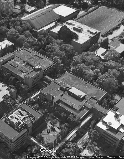
Within Pedestrian Sanctuary zones, place school campuses, distributed according to need.
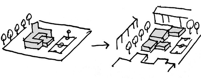
Problem-statement: School campuses too often turn their backs on the surrounding city or suburb, and create dead zones in the urban fabric as well as isolated, boring places for students.
Discussion:: Schools are certainly unique elements that have special requirements — among them safety for students, ample space for recreation, and sufficient size to provide for economies of management. Yet there is no fundamental reason that they must be isolated, or pose impenetrable barriers to the city.
Perhaps the best example of a necessarily large school is the university campus, which often must accommodate many thousands of students. Yet even large university campuses can be integrated directly into the walkable urban fabric, served by streetcars and other public transit, thus forming an integral part of the city separated from it by a semi-permeable (not solid) boundary.¹
Therefore:
Do not isolate school facilities and surround them with dead inactive edges, but weave them into the city fabric, providing stimulation to students and non-students alike. Wherever possible, put buildings on the edges, and where sports fields must go to the edges, build attractive pergolas and other structures to promote walkability. Assure that buildings are attractive at pedestrian scale, and offer interesting window views to surrounding streets.
Assure that the school campuses have a Walkable Streetscape with a well-articulated Place Network...
¹ It is helpful in this context to review patterns by Christopher Alexander and colleagues for a campus at the University of Oregon. See Alexander, C., Silverstein, M., Angel, S., Ishikawa, S., & Abrams, D. (1975). The Oregon Experiment, New York: Oxford University Press. The pattern descriptions given below are our own summaries:
Open University. Do not isolate the university by surrounding it with a boundary; instead, interweave at least one side of the campus into an adjoining city, if that is possible.
Student Housing Distribution. Locate some student housing within the center of the campus, with different percentages in regions as one moves away from the center. The first 500m radius containing ¼ of the resident students; ¼ in a ring between 500m and 800m radius; and the rest outside 800m.
University Shape And Diameter. If possible, situate classrooms within a central core of ½ km radius, and non-class activities such as administration, sports centers, and research offices outside.
Local Transport Areas. Give priority to pedestrian flow in the central core of the campus, within a radius of ½ - 1 km. Vehicular traffic here must be made to go on slow and circuitous roads.
Fabric Of Departments. While each academic department ought to have a home base, it should be able to spread over into other buildings and interlock with other departments.
For further reading see Salingaros, N.A. (2020). Planning, Complexity, and Welcoming Spaces — The Case of Campus Design. In Handbook on Planning and Complexity, De Roo, G., Yamu, C. and Zuidema, C. (Eds.) Cheltenham UK: Edward Elgar Publishers.
Mehaffy, M. et al. (2020). SCHOOL CAMPUS (pattern). In A New Pattern Language for Growing Regions. The Dalles: Sustasis Press. Available at https://pattern-language.wiki/.../School_Campus
SECTION I:
PATTERNS OF SCALE
1. REGIONAL PATTERNS
Define the large-scale spatial organization…
1.4. 400M THROUGH STREET NETWORK
2. URBAN PATTERNS
Establish essential urban characteristics…
3. STREET PATTERNS
Identify and allocate street types…
4. NEIGHBORHOOD PATTERNS
Define neighborhood-scale elements…
5. SPECIAL USE PATTERNS
Integrate unique urban elements with care…
6. PUBLIC SPACE PATTERNS
Establish the character of the crucial public realm…
7. BLOCK AND PLOT PATTERNS
Lay out the detailed structure of property lines…
8. STREETSCAPE PATTERNS
Configure the street as a welcoming place…
9. BUILDING PATTERNS
Lay out appropriate urban buildings…
10. BUILDING EDGE PATTERNS
Create interior and exterior connectivity…
10.1. INDOOR-OUTDOOR AMBIGUITY
SECTION II:
PATTERNS OF MULTIPLE SCALE
11. GEOMETRIC PATTERNS
Build in coherent geometries at all scales…
11.2. SMALL GROUPS OF ELEMENTS
12. AFFORDANCE PATTERNS
Build in user capacity to shape the environment…
13. RETROFIT PATTERNS
Revitalize and improve existing urban assets …
14. INFORMAL GROWTH PATTERNS
Accommodate “bottom-up” urban growth…
15. CONSTRUCTION PATTERNS
Use the building process to enrich the result…
SECTION III:
PATTERNS OF PROCESS
16. IMPLEMENTATION TOOL PATTERNS
Use tools to achieve successful results…
16.2. ENTITLEMENT STREAMLINING
16.3. NEIGHBORHOOD PLANNING CENTER
17. PROJECT ECONOMICS PATTERNS
Create flows of money that support urban quality…
17.4. ECONOMIES OF PLACE AND DIFFERENTIATION
18. PLACE GOVERNANCE PATTERNS
Processes for making and managing places…
18.3. PUBLIC-PRIVATE PLACE MANAGEMENT
19. AFFORDABILITY PATTERNS
Build in affordability for all incomes…
19.1. INTEGRATED AFFORDABILITY
20. NEW TECHNOLOGY PATTERNS
Integrate new systems without damaging old ones…
20.2. RESPONSIVE TRANSPORTATION NETWORK COMPANY


