3.2. Multi-Way Boulevard
Aus Pattern Language Wiki
At a scale smaller than the Mobility Corridor we need slower surface corridors that still accommodate a higher volume of vehicular traffic.
Problem-statement: The major surface arteries of cities can choke the life out of their neighborhoods.
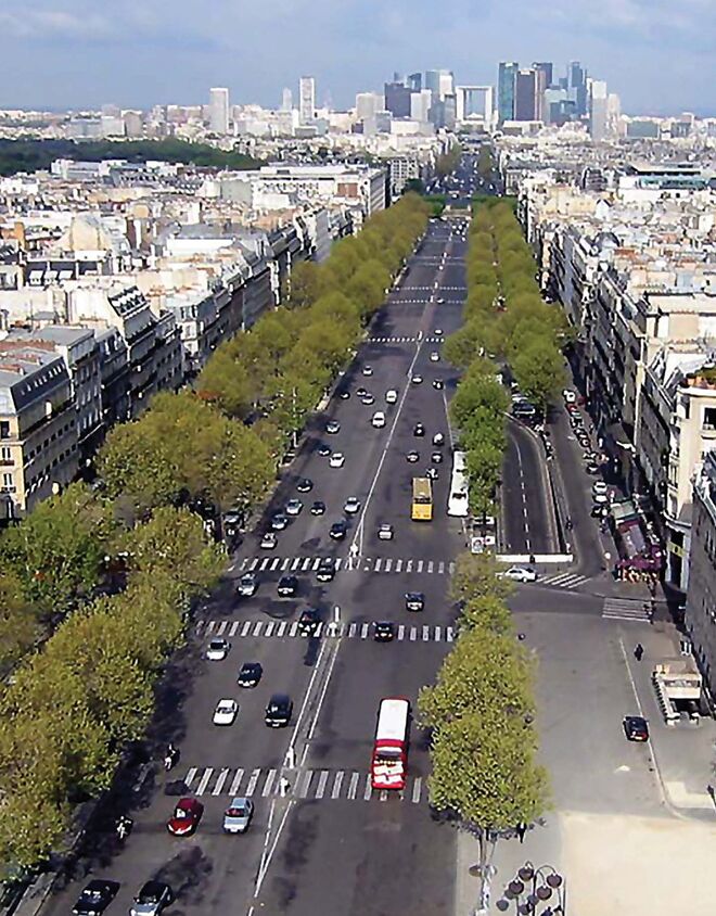
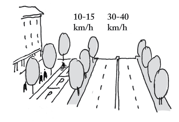
Discussion:: There are several problems with major surface arteries in cities. One is that they lack safe places for pedestrians to cross at regular enough intervals. Another is that they are so fast-moving that their edges create unsafe and unattractive zones for pedestrians. In addition, bicyclists also require another level of mobility, as well as vehicles that need to move more slowly in order to park, or to pick up pedestrian passengers. These multiple (sometimes conflicting) needs have been met with the pattern of a multi-way boulevard, combining faster travel lanes, slower “slip lanes,” and ample spaces for pedestrians and bicycles to travel, and to cross the faster-moving vehicular lanes safely.
Any high-speed vehicular corridor is of necessity out-of-bounds for the pedestrian. Even in urban situations where pedestrian crossings with traffic lights are in place, pedestrians will still feel threatened. The multi-way boulevard permits a mix of traffic and pedestrians as a compromise solution — but one that creates a more optimum balance between modes.¹
Therefore:
Periodically (typically at 800m or ½ mile spacing in both directions) create multi-way boulevards, consisting of several lanes for faster travel, slip lanes for slower travel and parking, wide pedestrian and bicycle sidewalk zones, and periodic crossings as frequent as possible, but not more than 400 meters apart. Make these beautiful urban spaces, with tree-lined medians and periodic focal points.
Space multi-way boulevards regularly between Avenue patterns, and at the edges of each Pedestrian Sanctuary. Provide ample medians and Street Trees…
¹ One of the best sources of information and research findings about multi-way boulevards is Jacobs, A., MacDonald, E. and Rofè, Y., The Boulevard Book. New York: Random House.
Image: via wikipedia.org by Luestling
Mehaffy, M. et al. (2020). MULTI-WAY BOULEVARD (pattern). In A New Pattern Language for Growing Regions. The Dalles: Sustasis Press. Available at https://pattern-language.wiki/.../Multi-Way_Boulevard
SECTION I:
PATTERNS OF SCALE
1. REGIONAL PATTERNS
Define the large-scale spatial organization…
1.4. 400M THROUGH STREET NETWORK
2. URBAN PATTERNS
Establish essential urban characteristics…
3. STREET PATTERNS
Identify and allocate street types…
4. NEIGHBORHOOD PATTERNS
Define neighborhood-scale elements…
5. SPECIAL USE PATTERNS
Integrate unique urban elements with care…
6. PUBLIC SPACE PATTERNS
Establish the character of the crucial public realm…
7. BLOCK AND PLOT PATTERNS
Lay out the detailed structure of property lines…
8. STREETSCAPE PATTERNS
Configure the street as a welcoming place…
9. BUILDING PATTERNS
Lay out appropriate urban buildings…
10. BUILDING EDGE PATTERNS
Create interior and exterior connectivity…
10.1. INDOOR-OUTDOOR AMBIGUITY
SECTION II:
PATTERNS OF MULTIPLE SCALE
11. GEOMETRIC PATTERNS
Build in coherent geometries at all scales…
11.2. SMALL GROUPS OF ELEMENTS
12. AFFORDANCE PATTERNS
Build in user capacity to shape the environment…
13. RETROFIT PATTERNS
Revitalize and improve existing urban assets …
14. INFORMAL GROWTH PATTERNS
Accommodate “bottom-up” urban growth…
15. CONSTRUCTION PATTERNS
Use the building process to enrich the result…
SECTION III:
PATTERNS OF PROCESS
16. IMPLEMENTATION TOOL PATTERNS
Use tools to achieve successful results…
16.2. ENTITLEMENT STREAMLINING
16.3. NEIGHBORHOOD PLANNING CENTER
17. PROJECT ECONOMICS PATTERNS
Create flows of money that support urban quality…
17.4. ECONOMIES OF PLACE AND DIFFERENTIATION
18. PLACE GOVERNANCE PATTERNS
Processes for making and managing places…
18.3. PUBLIC-PRIVATE PLACE MANAGEMENT
19. AFFORDABILITY PATTERNS
Build in affordability for all incomes…
19.1. INTEGRATED AFFORDABILITY
20. NEW TECHNOLOGY PATTERNS
Integrate new systems without damaging old ones…
20.2. RESPONSIVE TRANSPORTATION NETWORK COMPANY


